

New model increases vegetation prediction accuracy in Himalayan glacier melt zones
Greening dominated by grasslands as vegetation line shifts upwards by 7 – 28 m each year.
Climate warming has long been known to cause glaciers to melt and ‘retreat’ up the mountain to higher altitudes, leaving land that had been under ice for many millenia suddenly exposed to the air. The fate of this land varies – in many cases natural vegetation moves in, but in others local people cultivate the exposed land. In the Himalaya, the rate of vegetation shift up the mountainsides and the effects of topographic parameters on the exposed areas’ colonization by vegetation have yet to be quantified.
Researchers at the Conservation Research Institute, in partnership with colleagues in the Department of Applied Mathematics and Theoretical Physics and the Centre of Studies in Resource Engineering at IIT Bombay, have discovered that the mean vegetation line shifts upwards in altitude by between 7 – 28 m +/- 1.5m per year. Grassland expands into these newly exposed areas the most, with expansion rates influenced by soil moisture and the slope of the area being colonized.
The researchers used freely-available bistatic radar data to assess large scale glacier changes, which captures data irrespective of the weather and is far more comprehensive than more commonly used systems such as LIDAR, which is weather dependent, with limited effectiveness under cloud cover. They coupled this with in-person validation at 21 sites.
‘’Our focus was to define the drivers of the high rate of vegetation line shift in the Himalaya, and we’ve developed an empirical equation that enables us to predict vegetation dynamics reasonably accurately on a decade scale using glacier area, elevation change, slope, elevation, maximum mean temperature, runoff and soil moisture.” said Dr. Debmita Bandyopadhyay, research leader.
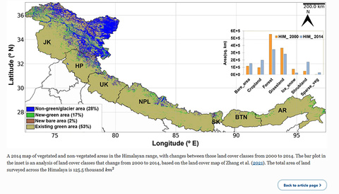
“To complement the data obtained from the commonly-used Normalised Difference Vegetation Index system, which suggests that mosses and shrubs dominate newly exposed areas, our study used Land Use Land Cover maps generated by the European Space Agency to show that grasslands dominate at higher altitudes, and we confirmed this by in-person measurements at selected sites. We not only quantify the rate at which the NDVI changes in each of the regions but also estimate the altitudes to which the grassland expands using hypsometry analysis."
The team also quantified the average rate of glacier mass loss at 10.9 +/- 1.2 Gigatons per year over the fourteen year period studied. Notable differences in loss trends between Himachal Pradesh (greater loss) and Jammu-Kashmir (limited loss) regions are thought to be due to different atmospheric circulation processes, and a clear trend of increased glacier ice loss as one moves further east along the range.
Read the paper:
Bandyopadhay, D., Mukherjee, S., Singh, G., Coombes, D.A. 2022. The rapid vegetation line shift in response to glacial dynamics and climate variability in Himalaya between 2000 and 2014. Environmental Monitoring and Assessment, Volume 195. Article number: 70 (2023). https://link.springer.com/article/10.1007/s10661-022-10577-9