

Avenues of trees of a single species are a striking feature in many towns and cities across England and Wales. These magnificent landscape features are frequently threatened by the arrival of invasive pests and pathogens which in the case of Dutch Elm Disease, saw the devastating loss of a single species from urbanised areas, within a decade. A new study by Webb and colleagues in the Epidemiology and Modelling Group considers how human activity and tree distribution across private and publicly owned land might affect the rate and direction of spread of invasive pests and pathogens.
“Developing amathematical model that can be used to predict disease spread in urban treescapes requires new approaches – we needed to build a model that could allow for differences in environmental stress and tree management between street, park and garden tree, and for variation in the potential for human-mediated spread due to intensity of human activity, traffic flow and buildings.”, said Cerian Webb, lead author of the paper.
To address these needs, the Cambridge team developed a spatially explicit computational model, that accounts for radial dispersal of pests and pathogens between trees, and human-mediated linear spread along the road and rail networks. Combining a tree inventory for Ipswich, provided by the Ipswich Borough Council Tree Team, with aerial data available under licence from The National Tree MapTM enabled the team to explore how a pest or pathogen might spread on a realistic urban landscape.
“The main difficulty we encountered with the landscape data was that although aerial data can be used to obtain a fairly accurate overview of where trees are located, identification of which species are present from aerial and satellite images is a much harder problem. Many pests and pathogens only feed or reproduce on particular species, so it is not enough to know where trees are present, we need to know whether the tree can act as a host.”
Analysis of the Ipswich-tree inventory revealed spatial clustering by species. Using the model, the team demonstrated how uncertainty in the distribution of tree species at risk in the landscape can have a big impact on the predicted rate and direction of spread of an invading pest or pathogen. By incorporating enhanced spread along road and rail networks, in addition to natural dispersal from hosts across the urban landscape, the team found that pests and pathogens could spread more rapidly across the environment than might be predicted by considering each route in isolation.
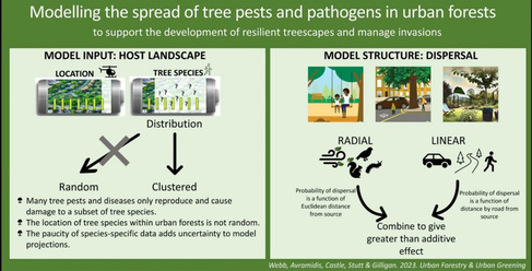
The modelling results have important implications for the development of strategies to manage and control outbreaks, highlighting the need not only to consider distance from infested trees but also how connected trees are via road and rail networks. The study also demonstrates the need for effective pest biosecurity measures at international ports and transportation hubs and to consider the potential impact of species composition and distribution in an epidemiological context when planning future planting initiatives.
“The majority of trees in a typical UK urban environments are privately owned (74% for Cambridge Tree data - Cambridge City Council ) our modelling highlights the need to consider trees in parks, private gardens and along highways in planning resilient urban treescapes. Tree owners can report tree health problems to Tree Alert (forestresearch.gov.uk).”
Read the paper
Webb, C.R., Avramidis, E., Castle, M.D., Stutt, R.O.H., Gilligan, C.A. 2023. Modelling the spread of tree pests and pathogens in urban forests. Urban Forestry & Urban Greening, 86, 128036, https://doi.org/10.1016/j.ufug.2023.128036.
Written by Cerian Webb and Alison Scott-Brown, from whom more details may be obtained.