Submitted by Helen C. Scott on Tue, 30/06/2015 - 14:11
Airborne laser scanning is emerging as an important tool for forest monitoring. By firing 200,000 pulses of light each second, and measuring how long they take to reflect of surfaces, laser scanners construct exquisitely detailed 3-D images of objects. Working with the RSPB and Cambridge Conservation Initiative, the Forest Ecology and Conservation Group have used ALS to scan African forest canopies and have shown the technology to be useful for detecting areas of forest that have been logged in the past.
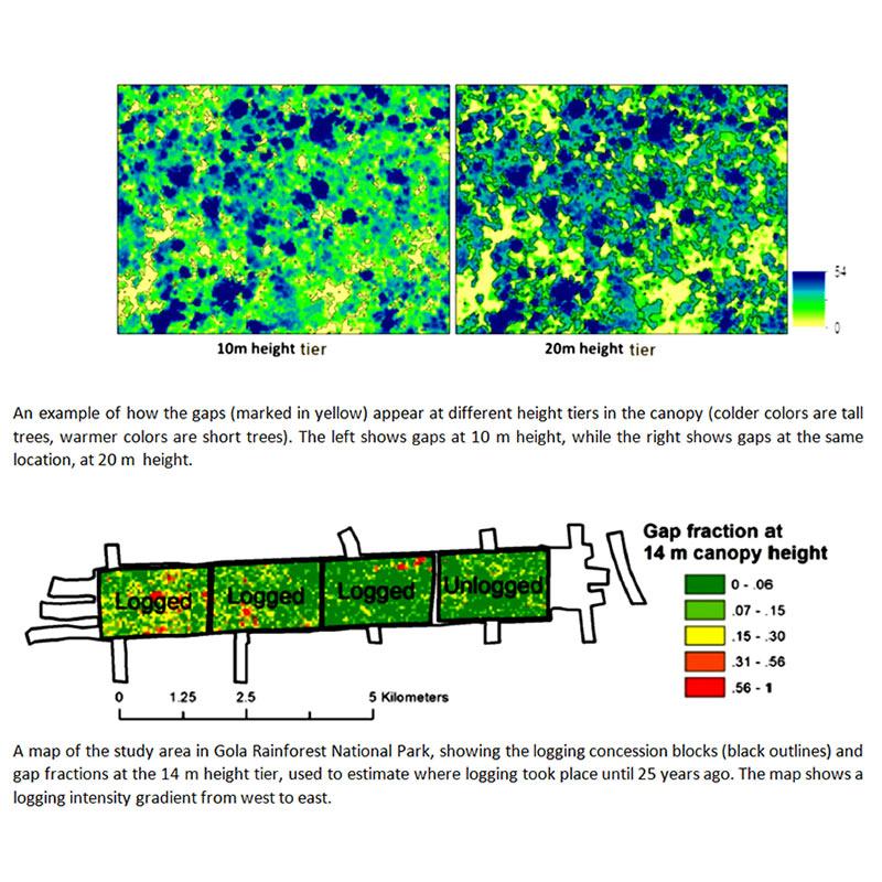
Gola forest in Sierra Leone, West Africa, underwent selective logging up until about 25 years ago. With the help of the RSPB, the forest has since become a national park and all logging activities have ceased. The group analyzed high resolution laser scans of the forest canopy to identify structural legacies of historic logging. Even 25 years after logged had ceased, the forest was slightly shorter and had more canopy gaps than old-growth forest nearby. Gap fraction (the fraction of the canopy below a given height) was found to be a particularly effective way of mapping selective logging from the airborne imagery. This technology could prove useful in conservation planning and implementation of programs to reduce greenhouse gas emissions, such as REDD+.
- Kent, R.; Lindsell, J.A.; Laurin, G.V.; Valentini, R.; Coomes, D.A. Airborne LiDAR Detects Selectively Logged Tropical Forest Even in an Advanced Stage of Recovery. Remote Sens. 2015, 7, 8348-8367.